- Title
- MODIS satellite derived global chlorophyll-a and Index for Coastal Eutrophica...
- Abstract
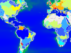
The Index for Coastal Eutrophication Potential (ICEP) is an indicator for the potential of riverine nutrient export to sustain new production of non-diatoms phytoplankton biomass; it is calculated by comparing the N, P and Si loading to the Redfield ratios expressing the requirements of marine diatoms growth.
A negative value of the ICEP indicates that Si is present in excess over the other nutrients and would thus indicate a low likelihood of HAB development. Positive values of ICEP indicate an excess of N or P over Si, which may lead to blooms of non-diatom, possibly harmful algae species. The ICEP represents the potential impact of the riverine delivery to the coastal zone.
Here the ICEP value is presented with the MODIS satellite derived chlorophyll-a measurements. Areas with high chlorophyll-a measurements often correspond to high ICEP values, including the Bay of Bengal, parts of south-east Asia and the Baltic Sea.
- Publication Date
- May 2, 2019, 8:42 a.m.
- Published
- Yes
- Featured
- No
- Name
- Global_Nutrient_Cycle
- Position
- Organization
- Location
- Voice
- Fax
- Identification Image
-
- Spatial Resolution
- ---
- Projetion System
- EPSG:4326
- Extension x0
- -104.8102721221
- Extension x1
- 70.9723815018
- Extension y0
- -48.0148207423
- Extension y1
- 73.4669893327
- Language
- English
- Supplemental Information
No information provided
- Name
- Global_Nutrient_Cycle
- Position
- Organization
- Location
- Voice
- Fax
- Link Online
- /maps/4099
- Metadata Page
- /maps/4099/metadata_detail
- Remote Thumbnail
- MODIS satellite derived global chlorophyll-a and Index for Coastal Eutrophication.png
- Remote Thumbnail
- MODIS satellite derived global chlorophyll-a and Index for Coastal Eutrophication.png
- Thumbnail
- MODIS satellite derived global chlorophyll-a and Index for Coastal Eutrophication.png
- Thumbnail
- MODIS satellite derived global chlorophyll-a and Index for Coastal Eutrophication.png
- Remote Thumbnail
- MODIS satellite derived global chlorophyll-a and Index for Coastal Eutrophication.png
- Remote Thumbnail
- MODIS satellite derived global chlorophyll-a and Index for Coastal Eutrophication.png
- Name
- Global_Nutrient_Cycle
- Position
- Organization
- Location
- Voice
- Fax