- Title
- Transboundary River Basins
- Abstract
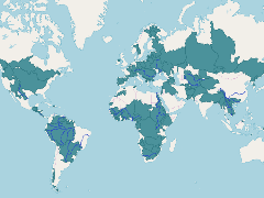
A map fo Transboundary River Basins. Data taken from the Transboundary Water Assessment Programme (http://www.geftwap.org/)
- Publication Date
- Nov. 12, 2018, 4:33 a.m.
- Category
- River Basins
- A river basin is an area of land drained by a river and its tributaries.
- Regions
- Global
- Published
- Yes
- Featured
- Yes
- Name
- Miles Macmillan-Lawler (miles_GRIDA)
- miles.macmillan-Lawler@grida.no
- Position
- Programme Lead
- Organization
- GRID-Arendal
- Location
- NOR
- Voice
- Fax
- Keywords
- Marine Spatial Analysis Data IWLEARN
- Identification Image
-
- Spatial Resolution
- ---
- Projetion System
- EPSG:4326
- Extension x0
- -87.8913268119
- Extension x1
- 87.8913268119
- Extension y0
- -61.5239287683
- Extension y1
- 61.5239287683
- Language
- English
- Supplemental Information
No information provided
- Spatial Representation Type
- vector data is used to represent geographic data
- Name
- Miles Macmillan-Lawler (miles_GRIDA)
- miles.macmillan-Lawler@grida.no
- Position
- Programme Lead
- Organization
- GRID-Arendal
- Location
- NOR
- Voice
- Fax
- Link Online
- /maps/3871
- Metadata Page
- /maps/3871/metadata_detail
- Thumbnail
- Transboundary River Basins.png
- Thumbnail
- Transboundary River Basins.png
- Remote Thumbnail
- Transboundary River Basins.png
- Remote Thumbnail
- Transboundary River Basins.png
- Name
- Miles Macmillan-Lawler (miles_GRIDA)
- miles.macmillan-Lawler@grida.no
- Position
- Programme Lead
- Organization
- GRID-Arendal
- Location
- NOR
- Voice
- Fax
- Keywords
- Marine Spatial Analysis Data IWLEARN