- Title
- Transboundary Aquifers
- Abstract
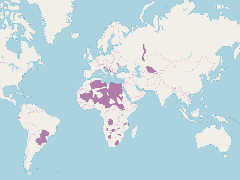
A map fo transboundary aquifers for the GEF IW projects. Aquifers are taken from the IGARC
- Publication Date
- Nov. 12, 2018, 2:35 a.m.
- Category
- Aquifers
- An aquifer is an underground layer of water-bearing rock. Water-bearing rocks are permeable, meaning that they have openings that liquids and gases can pass through. Sedimentary rock such as sandstone, as well as sand and gravel, are examples of water-bearing rock. The top of the water level in an aquifer is called the water table.
- Published
- Yes
- Featured
- Yes
- Name
- Miles Macmillan-Lawler (miles_GRIDA)
- miles.macmillan-Lawler@grida.no
- Position
- Programme Lead
- Organization
- GRID-Arendal
- Location
- NOR
- Voice
- Fax
- Keywords
- Marine Spatial Analysis Data IWLEARN
- Identification Image
-
- Spatial Resolution
- ---
- Projetion System
- EPSG:4326
- Extension x0
- -87.8913268119
- Extension x1
- 87.8913268119
- Extension y0
- -61.5239287683
- Extension y1
- 61.5239287683
- Language
- English
- Supplemental Information
No information provided
- Name
- Miles Macmillan-Lawler (miles_GRIDA)
- miles.macmillan-Lawler@grida.no
- Position
- Programme Lead
- Organization
- GRID-Arendal
- Location
- NOR
- Voice
- Fax
- Link Online
- /maps/3870
- Metadata Page
- /maps/3870/metadata_detail
- Thumbnail
- Transboundary Aquifers.png
- Thumbnail
- Transboundary Aquifers.png
- Remote Thumbnail
- Transboundary Aquifers.png
- Remote Thumbnail
- Transboundary Aquifers.png
- Name
- Miles Macmillan-Lawler (miles_GRIDA)
- miles.macmillan-Lawler@grida.no
- Position
- Programme Lead
- Organization
- GRID-Arendal
- Location
- NOR
- Voice
- Fax
- Keywords
- Marine Spatial Analysis Data IWLEARN