- Title
- Benguela Current LME seamounts
- Abstract
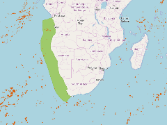
A map showing the seamounts identified by Harris etal (2014) in relation to the Benguela Current LME region
- Publication Date
- Nov. 28, 2017, 4:07 a.m.
- Category
- Oceans
- Ocean is defined as the body of salt water covering much of the Earth or a large quantity of something.
- Regions
- Namibia, South Africa, Angola
- Published
- Yes
- Featured
- No
- Name
- Miles Macmillan-Lawler (miles_GRIDA)
- miles.macmillan-Lawler@grida.no
- Position
- Programme Lead
- Organization
- GRID-Arendal
- Location
- NOR
- Voice
- Fax
- Keywords
- Marine Spatial Analysis Data IWLEARN
- Identification Image
-
- Spatial Resolution
- ---
- Projetion System
- EPSG:4326
- Extension x0
- -19.1605071594
- Extension x1
- 68.7308196525
- Extension y0
- -28.7190662797
- Extension y1
- -18.7309571860
- Language
- English
- Supplemental Information
No information provided
- Name
- Miles Macmillan-Lawler (miles_GRIDA)
- miles.macmillan-Lawler@grida.no
- Position
- Programme Lead
- Organization
- GRID-Arendal
- Location
- NOR
- Voice
- Fax
- Link Online
- /maps/3277
- Metadata Page
- /maps/3277/metadata_detail
- Remote Thumbnail
- Benguela Current LME seamounts.png
- Thumbnail
- Benguela Current LME seamounts.png
- Thumbnail
- Benguela Current LME seamounts.png
- Remote Thumbnail
- Benguela Current LME seamounts.png
- Remote Thumbnail
- Benguela Current LME seamounts.png
- Name
- Miles Macmillan-Lawler (miles_GRIDA)
- miles.macmillan-Lawler@grida.no
- Position
- Programme Lead
- Organization
- GRID-Arendal
- Location
- NOR
- Voice
- Fax
- Keywords
- Marine Spatial Analysis Data IWLEARN