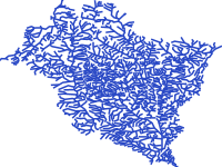
- Title
- vsip Volta River basin hydrology
- Abstract
This data was collated to support the Volta River Basin Strategic Action Programme Implementation Project (GEF ID 6964). The project objective is to strengthen transboundary water resources management in the Volta River Basin through the Volta Basin Authority, including implementation of priority actions of the Strategic Action Programme. This layer contains the hydrology of the volta river basin.
- License
- Not Specified
-
+ The original author did not specify a license.
- Publication Date
- May 31, 2019, 2:02 a.m.
- Type
- Vector Data
- Keywords
- Volta VSIP
- Category
- River Basins
- A river basin is an area of land drained by a river and its tributaries.
- Regions
- Africa, West Africa, Benin, Burkina Faso, Cote d'Ivoire, Ghana, Mali, Togo
- Published
- Yes
- Featured
- No
- Name
- volta
- Position
- Organization
- Location
- Voice
- Fax
- Spatial Resolution
- ---
- Projetion System
- EPSG:4326
- Extension x0
- -5.3244510000
- Extension x1
- 2.2483750000
- Extension y0
- 5.7609120000
- Extension y1
- 14.0383180000
- Maintenance Frequency
- Frequency Of Maintenance For The Data Is Not Known
- Purpose
Creation of maps of the Volta River basin.
- Language
- English
- Supplemental Information
No information provided
- Name
- volta
- Position
- Organization
- Location
- Voice
- Fax
- Link Online
- /layers/geonode:vsip_volta_hydrology
- Metadata Page
- /layers/geonode:vsip_volta_hydrology/metadata_detail
- Tiles
- vsip Volta River basin hydrology.tiles
- Legend
- vsip Volta River basin hydrology.png
- Thumbnail
- vsip Volta River basin hydrology.png
- Remote Thumbnail
- vsip Volta River basin hydrology.png
- View in Google Earth
- vsip Volta River basin hydrology.kml
- KML
- vsip Volta River basin hydrology.kml
- GeoJSON
- vsip Volta River basin hydrology.json
- Excel
- vsip Volta River basin hydrology.excel
- CSV
- vsip Volta River basin hydrology.csv
- GML 3.1.1
- vsip Volta River basin hydrology.gml
- GML 2.0
- vsip Volta River basin hydrology.gml
- Zipped Shapefile
- vsip Volta River basin hydrology.zip
- PNG
- vsip Volta River basin hydrology.png
- vsip Volta River basin hydrology.pdf
- JPEG
- vsip Volta River basin hydrology.jpg
- OGC WFS: geonode Service
- Geoservice OGC:WFS
- OGC WMS: geonode Service
- Geoservice OGC:WMS
- Name
- volta
- Position
- Organization
- Location
- Voice
- Fax
