- Title
- MRU_landcover
- Abstract
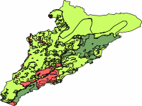
Land cover for the Mano River basin. Data provided by the Mano RIver Union ecosystem conservation and international water resources management project
- License
- Not Specified
-
+ The original author did not specify a license.
- Publication Date
- May 28, 2019, 9:44 a.m.
- Type
- Vector Data
- Keywords
- Guinea Land Use Liberia Sierra Leone
- Category
- River Basins
- A river basin is an area of land drained by a river and its tributaries.
- Regions
- West Africa, Guinea, Liberia, Sierra Leone
- Published
- Yes
- Featured
- No
- Name
- MRU_IWRM
- Position
- Organization
- Location
- Voice
- Fax
- Identification Image
-
- Spatial Resolution
- ---
- Projetion System
- EPSG:4326
- Extension x0
- -11.6147710850
- Extension x1
- -9.2686839248
- Extension y0
- 6.8534824384
- Extension y1
- 9.3117036039
- Maintenance Frequency
- Frequency Of Maintenance For The Data Is Not Known
- Purpose
to be used on basin scale maps
- Language
- English
- Data Quality
- the data quality is unknown
- Supplemental Information
No information provided
- Spatial Representation Type
- vector data is used to represent geographic data
- Name
- MRU_IWRM
- Position
- Organization
- Location
- Voice
- Fax
- Link Online
- /layers/geonode:landcover_mru
- Metadata Page
- /layers/geonode:landcover_mru/metadata_detail
- Remote Thumbnail
- MRU_landcover.png
- Tiles
- MRU_landcover.tiles
- Legend
- MRU_landcover.png
- Thumbnail
- MRU_landcover.png
- Remote Thumbnail
- MRU_landcover.png
- View in Google Earth
- MRU_landcover.kml
- KML
- MRU_landcover.kml
- GeoJSON
- MRU_landcover.json
- Excel
- MRU_landcover.excel
- CSV
- MRU_landcover.csv
- GML 3.1.1
- MRU_landcover.gml
- GML 2.0
- MRU_landcover.gml
- Zipped Shapefile
- MRU_landcover.zip
- PNG
- MRU_landcover.png
- MRU_landcover.pdf
- JPEG
- MRU_landcover.jpg
- OGC WFS: geonode Service
- Geoservice OGC:WFS
- OGC WMS: geonode Service
- Geoservice OGC:WMS
- Name
- MRU_IWRM
- Position
- Organization
- Location
- Voice
- Fax