- Title
- chlorophyll_a
- Abstract
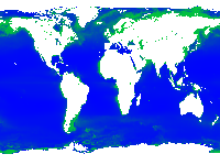
Downsampled layer of mean chlorophyll-a from MODIS Chlorophyll-a Concentration
This layer represents the near-surface concentration of chlorophyll-a in mg m-3, calculated using an empirical relationship derived from in situ measurements of chlor_a and blue-to-green band ratios of in situ remote sensing reflectances (Rrs). Implementation is contingent on the availability three or more sensor bands spanning the 440 - 570 nm spectral regime.
- License
- Not Specified
-
+ The original author did not specify a license.
- Publication Date
- May 2, 2019, 8:34 a.m.
- Type
- Raster Data
- Keywords
- chlorophyll-a Global Nutrient Cycle GNC
- Category
- Oceans
- Ocean is defined as the body of salt water covering much of the Earth or a large quantity of something.
- Regions
- Global
- Published
- Yes
- Featured
- No
- Name
- Global_Nutrient_Cycle
- Position
- Organization
- Location
- Voice
- Fax
- Identification Image
-
- Spatial Resolution
- ---
- Projetion System
- EPSG:4326
- Extension x0
- -180.0000000000
- Extension x1
- 180.0000000000
- Extension y0
- -90.0000000000
- Extension y1
- 90.0000000000
- Maintenance Frequency
- There Are No Plans To Update The Data
- Language
- English
- Supplemental Information
No information provided
- Spatial Representation Type
- grid data is used to represent geographic data
- Name
- Global_Nutrient_Cycle
- Position
- Organization
- Location
- Voice
- Fax
- Link Online
- /layers/geonode:chlorophyll_a
- Metadata Page
- /layers/geonode:chlorophyll_a/metadata_detail
- Tiles
- chlorophyll_a.tiles
- Legend
- chlorophyll_a.png
- Thumbnail
- chlorophyll_a.png
- Remote Thumbnail
- chlorophyll_a.png
- View in Google Earth
- chlorophyll_a.kml
- KML
- chlorophyll_a.kml
- GeoTIFF
- chlorophyll_a.geotiff
- GZIP
- chlorophyll_a.x-gzip
- PNG
- chlorophyll_a.png
- chlorophyll_a.pdf
- JPEG
- chlorophyll_a.jpg
- OGC WCS: geonode Service
- Geoservice OGC:WCS
- OGC WMS: geonode Service
- Geoservice OGC:WMS
- Name
- Global_Nutrient_Cycle
- Position
- Organization
- Location
- Voice
- Fax