- Title
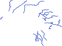
- 16 major rivers - Manila Bay
- Abstract
the 16 major rivers flowing into Manila Bay
- Publication Date
- Nov. 21, 2017, 5:04 p.m.
- Type
- Vector Data
- Category
- River Basins
- A river basin is an area of land drained by a river and its tributaries.
- Published
- Yes
- Featured
- No
- Name
- gridapublisher
- deviirme@gmail.com
- Position
- Organization
- Location
- Voice
- Fax
- Identification Image
-
- Spatial Resolution
- ---
- Projetion System
- EPSG:4326
- Extension x0
- 120.5355700403
- Extension x1
- 121.1116590518
- Extension y0
- 14.2029087111
- Extension y1
- 14.9827043234
- Language
- English
- Supplemental Information
No information provided
- Name
- gridapublisher
- deviirme@gmail.com
- Position
- Organization
- Location
- Voice
- Fax
- Link Online
- /layers/geonode:_16_major_rivers_1
- Metadata Page
- /layers/geonode:_16_major_rivers_1/metadata_detail
- Tiles
- 16 major rivers - Manila Bay.tiles
- Legend
- 16 major rivers - Manila Bay.png
- Thumbnail
- 16 major rivers - Manila Bay.png
- Remote Thumbnail
- 16 major rivers - Manila Bay.png
- View in Google Earth
- 16 major rivers - Manila Bay.kml
- KML
- 16 major rivers - Manila Bay.kml
- GeoJSON
- 16 major rivers - Manila Bay.json
- Excel
- 16 major rivers - Manila Bay.excel
- CSV
- 16 major rivers - Manila Bay.csv
- GML 3.1.1
- 16 major rivers - Manila Bay.gml
- GML 2.0
- 16 major rivers - Manila Bay.gml
- Zipped Shapefile
- 16 major rivers - Manila Bay.zip
- PNG
- 16 major rivers - Manila Bay.png
- 16 major rivers - Manila Bay.pdf
- JPEG
- 16 major rivers - Manila Bay.jpg
- OGC WFS: geonode Service
- Geoservice OGC:WFS
- OGC WMS: geonode Service
- Geoservice OGC:WMS
- Name
- gridapublisher
- deviirme@gmail.com
- Position
- Organization
- Location
- Voice
- Fax