- Title
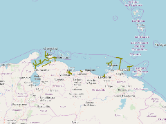
- TM-VENEZUELA-Líneas de oleoductos
- Abstract
El conjunto de datos contenidos en este archivo corresponde a la posible ubicación de fututos oleoductos costa afuera del área correspondiente al Mar Caribe venezolano hasta una latitud de trece grados norte.
- Publication Date
- May 5, 2019, 2:20 p.m.
- Type
- Data
- Keywords
- Actividad petrolera INTECMAR Líneas de oleoductos Oleoductos Venezuela
- Published
- Yes
- Featured
- No
- Name
- gridanode
- devrsgis@gmail.com
- Position
- Organization
- GRID-Arendal
- Location
- Voice
- Fax
- Identification Image
-
- Spatial Resolution
- ---
- Projetion System
- EPSG:900913
- Extension x0
- -71.8296356201
- Extension x1
- -61.8079109192
- Extension y0
- 9.9844036102
- Extension y1
- 12.5028085709
- Language
- English
- Supplemental Information
No information provided
- Name
- gridanode
- devrsgis@gmail.com
- Position
- Organization
- GRID-Arendal
- Location
- Voice
- Fax
- Link Online
- /layers/Caribbean_Marine_Atlas:geonode:lineas_oleoductos
- Metadata Page
- /layers/Caribbean_Marine_Atlas:geonode:lineas_oleoductos/metadata_detail
- Thumbnail
- TM-VENEZUELA-Líneas de oleoductos.png
- Name
- gridanode
- devrsgis@gmail.com
- Position
- Organization
- GRID-Arendal
- Location
- Voice
- Fax