- Title
- BM-BRB_Land Use Classification - 1997-1:10000
- Abstract
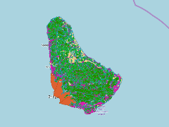
This dataset shows Land use classification based on ground truthed aerial photogaphy. They are approximately five classifications. This data was provided by the Coastal Zone Management Unit of Barbados ca.1997.
- Publication Date
- May 5, 2019, 2:20 p.m.
- Type
- Data
- Keywords
- Land cover classification Land Management Land Use
- Published
- Yes
- Featured
- No
- Name
- gridanode
- devrsgis@gmail.com
- Position
- Organization
- GRID-Arendal
- Location
- Voice
- Fax
- Identification Image
-
- Spatial Resolution
- ---
- Projetion System
- EPSG:900913
- Extension x0
- -59.6513944619
- Extension x1
- -59.4191690344
- Extension y0
- 13.0436228915
- Extension y1
- 13.3370517638
- Language
- English
- Supplemental Information
No information provided
- Name
- gridanode
- devrsgis@gmail.com
- Position
- Organization
- GRID-Arendal
- Location
- Voice
- Fax
- Link Online
- /layers/Caribbean_Marine_Atlas:geonode:land_use_wgs_84
- Metadata Page
- /layers/Caribbean_Marine_Atlas:geonode:land_use_wgs_84/metadata_detail
- Thumbnail
- BM-BRB_Land Use Classification - 1997-1:10000.png
- Name
- gridanode
- devrsgis@gmail.com
- Position
- Organization
- GRID-Arendal
- Location
- Voice
- Fax