- Title
- TM-BRB_Ground Water Protection Zones - 1997-1:10000
- Abstract
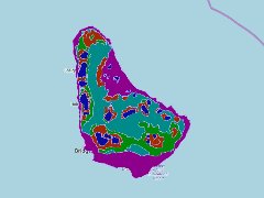
This dataset shows groundwater protection zones digitized from Barbados Water Authority 1:50000 maps, located around the island c.a 1998
- Publication Date
- May 5, 2019, 2:20 p.m.
- Type
- Data
- Keywords
- features ground_water_zones_wgs842
- Published
- Yes
- Featured
- No
- Name
- gridanode
- devrsgis@gmail.com
- Position
- Organization
- GRID-Arendal
- Location
- Voice
- Fax
- Identification Image
-
- Spatial Resolution
- ---
- Projetion System
- EPSG:900913
- Extension x0
- -59.6511781810
- Extension x1
- -59.4191105265
- Extension y0
- 13.0435880864
- Extension y1
- 13.3370498145
- Language
- English
- Supplemental Information
No information provided
- Name
- gridanode
- devrsgis@gmail.com
- Position
- Organization
- GRID-Arendal
- Location
- Voice
- Fax
- Link Online
- /layers/Caribbean_Marine_Atlas:geonode:ground_water_zones_wgs842
- Metadata Page
- /layers/Caribbean_Marine_Atlas:geonode:ground_water_zones_wgs842/metadata_detail
- Thumbnail
- TM-BRB_Ground Water Protection Zones - 1997-1:10000.png
- Name
- gridanode
- devrsgis@gmail.com
- Position
- Organization
- GRID-Arendal
- Location
- Voice
- Fax