- Title
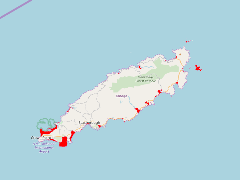
- TV_TTO_Tobago_ICZM_terrestrial_zone_T1_area_of_immediate_impact_2014_25000
- Abstract
In the development of the Integrated Coastal Zone policy for Trinidad and Tobago zones were needed to develop targeted policies. This zone was determined largely based upon elevation, threats from storm surges and projected sea level rise.
- Publication Date
- May 5, 2019, 2:16 p.m.
- Type
- Data
- Keywords
- ICZM Trinidad and Tobago
- Published
- Yes
- Featured
- No
- Name
- gridanode
- devrsgis@gmail.com
- Position
- Organization
- GRID-Arendal
- Location
- Voice
- Fax
- Identification Image
-
- Spatial Resolution
- ---
- Projetion System
- EPSG:900913
- Extension x0
- -60.8456348440
- Extension x1
- -60.4928673265
- Extension y0
- 11.1342008890
- Extension y1
- 11.3618271393
- Language
- English
- Supplemental Information
No information provided
- Name
- gridanode
- devrsgis@gmail.com
- Position
- Organization
- GRID-Arendal
- Location
- Voice
- Fax
- Link Online
- /layers/Caribbean_Marine_Atlas:geonode:a1
- Metadata Page
- /layers/Caribbean_Marine_Atlas:geonode:a1/metadata_detail
- Thumbnail
- TV_TTO_Tobago_ICZM_terrestrial_zone_T1_area_of_immediate_impact_2014_25000.png
- Name
- gridanode
- devrsgis@gmail.com
- Position
- Organization
- GRID-Arendal
- Location
- Voice
- Fax