- Title
- CLME: TV_WCR_Drainage area ALL (M)_20171201_noscale
- Abstract
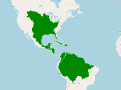
This shapefile shows the terrestrial area that drains to the whole Wider Caribbean Region. This area include large portions of the North American and South American continents and its main rivers, which contribute huge amounts of sediments, nutrients and contaminants to the sea.
- Publication Date
- May 5, 2019, 2:27 p.m.
- Type
- Data
- Keywords
- CLME+ terrestrial drainage
- Published
- Yes
- Featured
- No
- Name
- gridanode
- devrsgis@gmail.com
- Position
- Organization
- GRID-Arendal
- Location
- Voice
- Fax
- Identification Image
-
- Spatial Resolution
- ---
- Projetion System
- EPSG:900913
- Extension x0
- -113.9199981689
- Extension x1
- -40.1455078125
- Extension y0
- -20.4749755859
- Extension y1
- 49.6800003052
- Language
- English
- Supplemental Information
No information provided
- Name
- gridanode
- devrsgis@gmail.com
- Position
- Organization
- GRID-Arendal
- Location
- Voice
- Fax
- Link Online
- /layers/Caribbean_Marine_Atlas:geonode:tv_wcr_drainage_areaall_m_20171201_scale
- Metadata Page
- /layers/Caribbean_Marine_Atlas:geonode:tv_wcr_drainage_areaall_m_20171201_scale/metadata_detail
- Thumbnail
- CLME: TV_WCR_Drainage area ALL (M)_20171201_noscale.png
- Name
- gridanode
- devrsgis@gmail.com
- Position
- Organization
- GRID-Arendal
- Location
- Voice
- Fax