- Title
- TV_TTO_Trinidad_coastline_type
- Abstract
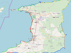
The coastal areas of Trinidad have been classified into categories based on morphology and their vulnerability to spilled oil. The index used in this report combines geological and biological sensitivities to oil spill impacts. The least sensitive to long term oil spill damage is 1, and the most sensitive is 10.
- Publication Date
- May 5, 2019, 2:26 p.m.
- Type
- Data
- Keywords
- coastline type mangrove rip rap rocky platforms rocky shores sandy beaches sea walls tidal flats
- Published
- Yes
- Featured
- No
- Name
- gridanode
- devrsgis@gmail.com
- Position
- Organization
- GRID-Arendal
- Location
- Voice
- Fax
- Identification Image
-
- Spatial Resolution
- ---
- Projetion System
- EPSG:900913
- Extension x0
- -61.9301464280
- Extension x1
- -60.9090855306
- Extension y0
- 10.0437388876
- Extension y1
- 10.8443741793
- Language
- English
- Supplemental Information
No information provided
- Name
- gridanode
- devrsgis@gmail.com
- Position
- Organization
- GRID-Arendal
- Location
- Voice
- Fax
- Link Online
- /layers/Caribbean_Marine_Atlas:geonode:tv_trinidad_coastline_type
- Metadata Page
- /layers/Caribbean_Marine_Atlas:geonode:tv_trinidad_coastline_type/metadata_detail
- Thumbnail
- TV_TTO_Trinidad_coastline_type.png
- Name
- gridanode
- devrsgis@gmail.com
- Position
- Organization
- GRID-Arendal
- Location
- Voice
- Fax