- Title
- TM_Sea level change (NOAA Laboratory for Satellite Altimetry )
- Abstract
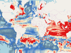
The following maps provide estimates of sea level rise based on measurements from satellite radar altimeters. The local trends were estiamted using data from TOPEX/Poseidon (T/P), Jason-1, and Jason-2, which have monitored the same ground track since 1992.
An inverted barometer has been applied. The estimates of sea level rise do not include glacial isostatic adjustment effects on the geoid, which are modeled to be +0.2 to +0.5 mm/year when globally averaged.
- Publication Date
- May 5, 2019, 2:22 p.m.
- Type
- Data
- Keywords
- Level Rise Sea
- Category
- Oceans
- Ocean is defined as the body of salt water covering much of the Earth or a large quantity of something.
- Published
- Yes
- Featured
- Yes
- Name
- gridanode
- devrsgis@gmail.com
- Position
- Organization
- GRID-Arendal
- Location
- Voice
- Fax
- Identification Image
-
- Spatial Resolution
- ---
- Projetion System
- EPSG:900913
- Extension x0
- -180.0000000000
- Extension x1
- 180.0000000000
- Extension y0
- -85.0000000000
- Extension y1
- 85.0000000000
- Language
- English
- Supplemental Information
No information provided
- Name
- gridanode
- devrsgis@gmail.com
- Position
- Organization
- GRID-Arendal
- Location
- Voice
- Fax
- Link Online
- /layers/Caribbean_Marine_Atlas:geonode:slr_map_txj1j2
- Metadata Page
- /layers/Caribbean_Marine_Atlas:geonode:slr_map_txj1j2/metadata_detail
- Thumbnail
- TM_Sea level change (NOAA Laboratory for Satellite Altimetry ).png
- Name
- gridanode
- devrsgis@gmail.com
- Position
- Organization
- GRID-Arendal
- Location
- Voice
- Fax