- Title
- CLME: TV_WCR_WECAFC area_20171121_noscale
- Abstract
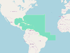
This layer displays the area of competence of the Western Central Atlantic Fishery Commission (WECAFC). It includes FAO Statistical Area 31 and the northern part of Statistical Area 41.
The WECAFC competence area covers the entire CLME+ region plus the Gulf of Mexico LME.
- Publication Date
- May 5, 2019, 2:22 p.m.
- Type
- Data
- Keywords
- CLME+ FAO Regional fisheries bodies
- Published
- Yes
- Featured
- No
- Name
- gridanode
- devrsgis@gmail.com
- Position
- Organization
- GRID-Arendal
- Location
- Voice
- Fax
- Identification Image
-
- Spatial Resolution
- ---
- Projetion System
- EPSG:900913
- Extension x0
- -97.8882700000
- Extension x1
- -20.0000000000
- Extension y0
- -10.0000000000
- Extension y1
- 36.0000000000
- Language
- English
- Supplemental Information
No information provided
- Name
- gridanode
- devrsgis@gmail.com
- Position
- Organization
- GRID-Arendal
- Location
- Voice
- Fax
- Link Online
- /layers/Caribbean_Marine_Atlas:geonode:rfb_wecafc_1
- Metadata Page
- /layers/Caribbean_Marine_Atlas:geonode:rfb_wecafc_1/metadata_detail
- Thumbnail
- CLME: TV_WCR_WECAFC area_20171121_noscale.png
- Name
- gridanode
- devrsgis@gmail.com
- Position
- Organization
- GRID-Arendal
- Location
- Voice
- Fax