- Title
- TM-VENEZUELA-Futuros pozos de explotación
- Abstract
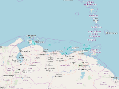
El conjunto de datos contenidos en este archivo corresponde a futuros pozos de explotación costa afuera del área correspondiente al Mar Caribe venezolano hasta una latitud de trece grados norte.
- Publication Date
- May 5, 2019, 2:22 p.m.
- Type
- Data
- Keywords
- Actividad petrolera INTECMAR Pozos Venezuela
- Published
- Yes
- Featured
- No
- Name
- gridanode
- devrsgis@gmail.com
- Position
- Organization
- GRID-Arendal
- Location
- Voice
- Fax
- Identification Image
-
- Spatial Resolution
- ---
- Projetion System
- EPSG:900913
- Extension x0
- -70.3939437866
- Extension x1
- -61.7426834106
- Extension y0
- 10.2117929459
- Extension y1
- 12.5062103271
- Language
- English
- Supplemental Information
No information provided
- Name
- gridanode
- devrsgis@gmail.com
- Position
- Organization
- GRID-Arendal
- Location
- Voice
- Fax
- Link Online
- /layers/Caribbean_Marine_Atlas:geonode:pzs_expl
- Metadata Page
- /layers/Caribbean_Marine_Atlas:geonode:pzs_expl/metadata_detail
- Thumbnail
- TM-VENEZUELA-Futuros pozos de explotación.png
- Name
- gridanode
- devrsgis@gmail.com
- Position
- Organization
- GRID-Arendal
- Location
- Voice
- Fax