- Title
- BV_JAM_Jamaica, Caribbean, Protected Areas, 2010, 1:1,280,000
- Abstract
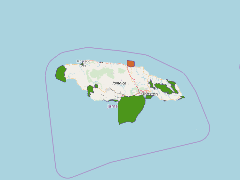
Protected Areas across Jamaica, including game reserves, protected areas, marine parks, national parks and forest reserves. Both declared and proposed protected areas are shown, along with details pertaining to the act under which each was declared and the date of declaration.
National Environment and Planning Agency (NEPA) and Mona GeoInformatics Institute (MGI)
- Publication Date
- May 5, 2019, 2:22 p.m.
- Type
- Data
- Keywords
- features protected_areas
- Published
- Yes
- Featured
- No
- Name
- gridanode
- devrsgis@gmail.com
- Position
- Organization
- GRID-Arendal
- Location
- Voice
- Fax
- Identification Image
-
- Spatial Resolution
- ---
- Projetion System
- EPSG:900913
- Extension x0
- -78.4052600330
- Extension x1
- -76.1805022961
- Extension y0
- 17.4607708345
- Extension y1
- 18.5194441186
- Language
- English
- Supplemental Information
No information provided
- Name
- gridanode
- devrsgis@gmail.com
- Position
- Organization
- GRID-Arendal
- Location
- Voice
- Fax
- Link Online
- /layers/Caribbean_Marine_Atlas:geonode:protected_areas
- Metadata Page
- /layers/Caribbean_Marine_Atlas:geonode:protected_areas/metadata_detail
- Thumbnail
- BV_JAM_Jamaica, Caribbean, Protected Areas, 2010, 1:1,280,000.png
- Name
- gridanode
- devrsgis@gmail.com
- Position
- Organization
- GRID-Arendal
- Location
- Voice
- Fax