- Title
- TM-BRB_Oceanographic and Meteorological Stations-2017
- Abstract
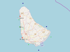
This dataset displays existing oceangraphic and meteorological station locations located around the island of Barbados. These stations are categorised into three categories. These are Acoustic Wave and Current Profilers, Sea Level Stations and Directional Wave Buoys. This data was provided by the Coastal Zone Management Unit of Barbados ca.2017.
- Publication Date
- May 5, 2019, 2:21 p.m.
- Type
- Data
- Keywords
- features locations_2
- Published
- Yes
- Featured
- No
- Name
- gridanode
- devrsgis@gmail.com
- Position
- Organization
- GRID-Arendal
- Location
- Voice
- Fax
- Identification Image
-
- Spatial Resolution
- ---
- Projetion System
- EPSG:900913
- Extension x0
- -59.6529666700
- Extension x1
- -59.4172500000
- Extension y0
- 13.0180000000
- Extension y1
- 13.3570500000
- Language
- English
- Supplemental Information
No information provided
- Name
- gridanode
- devrsgis@gmail.com
- Position
- Organization
- GRID-Arendal
- Location
- Voice
- Fax
- Link Online
- /layers/Caribbean_Marine_Atlas:geonode:locations_2
- Metadata Page
- /layers/Caribbean_Marine_Atlas:geonode:locations_2/metadata_detail
- Thumbnail
- TM-BRB_Oceanographic and Meteorological Stations-2017.png
- Name
- gridanode
- devrsgis@gmail.com
- Position
- Organization
- GRID-Arendal
- Location
- Voice
- Fax