- Title
- CLME: TV_WCR_Cartagena Convention area_20171121_noscale
- Abstract
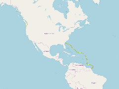
This line is an approximation of the outer limits of the Cartagena Convention area, defined by the Convention's text is "The "Convention area" means the marine environment of the Gulf of Mexico, the Caribbean Sea and the areas of the Atlantic Ocean adjacent thereto, south of 30 north latitude and within 200 nautical miles of the Atlantic coasts of the States referred to in article 25 of the Convention".
- Publication Date
- May 5, 2019, 2:18 p.m.
- Type
- Data
- Keywords
- CLME+ ratifications and endorsements Regional Governance Framework
- Published
- Yes
- Featured
- No
- Name
- gridanode
- devrsgis@gmail.com
- Position
- Organization
- GRID-Arendal
- Location
- Voice
- Fax
- Identification Image
-
- Spatial Resolution
- ---
- Projetion System
- EPSG:900913
- Extension x0
- -124.7630560000
- Extension x1
- -49.4178293540
- Extension y0
- 4.0596505028
- Extension y1
- 48.7887220000
- Language
- English
- Supplemental Information
No information provided
- Name
- gridanode
- devrsgis@gmail.com
- Position
- Organization
- GRID-Arendal
- Location
- Voice
- Fax
- Link Online
- /layers/Caribbean_Marine_Atlas:geonode:conv_area_contour_split_1
- Metadata Page
- /layers/Caribbean_Marine_Atlas:geonode:conv_area_contour_split_1/metadata_detail
- Thumbnail
- CLME: TV_WCR_Cartagena Convention area_20171121_noscale.png
- Name
- gridanode
- devrsgis@gmail.com
- Position
- Organization
- GRID-Arendal
- Location
- Voice
- Fax