- Title
- CLME: TV_WIDER CARIBBEAN_CARTAGENA CONV_2017
- Abstract
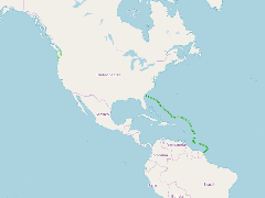
This layer displays the approximate outer limits of the Cartagena Convention area, as defined in the text of the Convention.
The full name of this Convention is "Cartagena Convention for the Protection and Development of the Marine Environment of the Greater Caribbean region".
- Publication Date
- May 5, 2019, 2:18 p.m.
- Type
- Data
- Keywords
- Cartagena Convention governance architecture
- Published
- Yes
- Featured
- No
- Name
- gridanode
- devrsgis@gmail.com
- Position
- Organization
- GRID-Arendal
- Location
- Voice
- Fax
- Identification Image
-
- Spatial Resolution
- ---
- Projetion System
- EPSG:900913
- Extension x0
- -124.7630560000
- Extension x1
- -49.4178293540
- Extension y0
- 4.0596505028
- Extension y1
- 48.7887220000
- Language
- English
- Supplemental Information
No information provided
- Name
- gridanode
- devrsgis@gmail.com
- Position
- Organization
- GRID-Arendal
- Location
- Voice
- Fax
- Link Online
- /layers/Caribbean_Marine_Atlas:geonode:conv_area_contour_split
- Metadata Page
- /layers/Caribbean_Marine_Atlas:geonode:conv_area_contour_split/metadata_detail
- Thumbnail
- CLME: TV_WIDER CARIBBEAN_CARTAGENA CONV_2017.png
- Name
- gridanode
- devrsgis@gmail.com
- Position
- Organization
- GRID-Arendal
- Location
- Voice
- Fax