- Title
- CLME: BV_WCR_ISOBATH_20171207_noscale
- Abstract
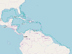
This line represents the depth of the ocean floor at 200 meters.
- Publication Date
- May 5, 2019, 2:18 p.m.
- Type
- Data
- Keywords
- Bathymetry CLME+
- Published
- Yes
- Featured
- No
- Name
- gridanode
- devrsgis@gmail.com
- Position
- Organization
- GRID-Arendal
- Location
- Voice
- Fax
- Identification Image
-
- Spatial Resolution
- ---
- Projetion System
- EPSG:900913
- Extension x0
- -97.4367569652
- Extension x1
- -34.4867447582
- Extension y0
- -7.2081890520
- Extension y1
- 32.7122802734
- Language
- English
- Supplemental Information
No information provided
- Name
- gridanode
- devrsgis@gmail.com
- Position
- Organization
- GRID-Arendal
- Location
- Voice
- Fax
- Link Online
- /layers/Caribbean_Marine_Atlas:geonode:bv_wcr_isobath_20171207_noscale
- Metadata Page
- /layers/Caribbean_Marine_Atlas:geonode:bv_wcr_isobath_20171207_noscale/metadata_detail
- Thumbnail
- CLME: BV_WCR_ISOBATH_20171207_noscale.png
- Name
- gridanode
- devrsgis@gmail.com
- Position
- Organization
- GRID-Arendal
- Location
- Voice
- Fax