- Title
- CLME: BV_Americas_Country_boundaries_20171207_noscale
- Abstract
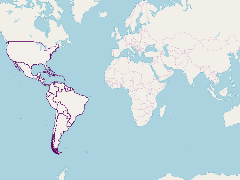
This layer shows the limits of countries in the American continent, except for Alaska and Canada.
Data from the Global Administrative Areas Database (http://www.gadm.org/)
The boundaries shown here are not official boundaries.
- Publication Date
- May 5, 2019, 2:17 p.m.
- Type
- Data
- Keywords
- CLME+ Countries
- Published
- Yes
- Featured
- No
- Name
- gridanode
- devrsgis@gmail.com
- Position
- Organization
- GRID-Arendal
- Location
- Voice
- Fax
- Identification Image
-
- Spatial Resolution
- ---
- Projetion System
- EPSG:900913
- Extension x0
- -178.3036041260
- Extension x1
- 166.6575012207
- Extension y0
- -55.9840278625
- Extension y1
- 49.3833007812
- Language
- English
- Supplemental Information
No information provided
- Name
- gridanode
- devrsgis@gmail.com
- Position
- Organization
- GRID-Arendal
- Location
- Voice
- Fax
- Link Online
- /layers/Caribbean_Marine_Atlas:geonode:bv_americas_country_boundaries_20171207_noscale
- Metadata Page
- /layers/Caribbean_Marine_Atlas:geonode:bv_americas_country_boundaries_20171207_noscale/metadata_detail
- Thumbnail
- CLME: BV_Americas_Country_boundaries_20171207_noscale.png
- Name
- gridanode
- devrsgis@gmail.com
- Position
- Organization
- GRID-Arendal
- Location
- Voice
- Fax