- Thumbnail
- Resource ID
- 1d9e652a-8157-11e9-8d7d-000d3ab6a624
- Title
- MRU_landcover
- Date
- May 28, 2019, 9:44 a.m., Publication
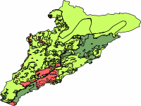
- Abstract
- Land cover for the Mano River basin. Data provided by the Mano RIver Union ecosystem conservation and international water resources management project
- Edition
- --
- Owner
- MRU_IWRM
- Point of Contact
- Purpose
- to be used on basin scale maps
- Maintenance Frequency
- unknown
- Type
- vector
- Restrictions
- None
- License
- Not Specified
- Language
- eng
- Temporal Extent
- Start
- --
- End
- --
- Supplemental Information
- No information provided
- Data Quality
- the data quality is unknown
- Extent
-
- long min: -11.6147710850
- long max: -9.2686839248
- lat min: 6.8534824384
- lat max: 9.3117036039
- Spatial Reference System Identifier
- EPSG:4326
- Keywords
- no keywords
- Category
- River Basins
- Regions
-
West Africa
,
Guinea
,
Liberia
,
Sierra Leone